 By Stephen D. Nagiewicz, coauthor of “Robert J. Walker”: The History and Archaeology of a U.S. Coast Survey Steamship
This book is available at a discount price and free shipping as part of our SAA virtual booth. Order here and use code SAA20, valid through June 30.
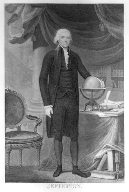
Thomas Jefferson was one of our nation’s Founding Fathers; he was our third President (1801–1809); and—a trivia answer—he was our country’s second vice president (1797–1801). He is also considered our nation’s first true scientist. He recognized the need for accurate navigational charts of the nation’s coastlines. On February 10, 1807, President Jefferson signed “an act to provide for surveying the coasts of the United States,” and created the Coast Survey, the first scientific organization of the nation.
Like most new government entities, the Coast Survey was not without growing pains. Tensions existed between civilians and the U.S. Navy, which ran the organization until 1832. Alexander Dallas Bache, the second superintendent (1843–1867) and great-grandson of Benjamin Franklin, got the organization in full operation as the civilian-managed U.S. Coast Survey. During the next twenty years, it attracted notable scientists and naturalists, including Louis Agassiz, John Muir, and James McNeill Whistler. Throughout this time, vessels like the Walker were surveying the coastlines and providing charts to help navigation and commerce.
In 1970, President Richard M. Nixon created the National Oceanic and Atmospheric Administration (NOAA), which would become the permanent home for the Office of Coast Survey. Today, hydrographers and staff at the NOAA’s Office of Coast Survey annually survey 3,000 square miles of coastline. Additionally, this organization manages over 43,000 square nautical miles of United States coastal waters which are critical to navigation, and more than 1,000 nautical charts in print or digital publications that cover 93,000 miles of United States coastlines and over 3.6 million square miles of United States waters. These statistics gloss over the real work, which makes taking the depth readings the easy part. Add to this the complicated math that will draw the charts’ contours showing depth changes of the sea-bottom, as well as tidal changes, water currents, and other environmental effects. The task is enormous and it is done every day, every year.
World Hydrography Day commemorates the work of scientists and hydrographers, whose efforts map the world’s waterways. This day, June 21, was recognized by the United Nations General Assembly in 2005, adopted by Resolution A/RES/60/30 Oceans and the law of the sea, recognizing the establishment of World Hydrography Day by the International Hydrographic Organization (IHO). The IHO was established on June 21 in 1921 and develops the technical standards, policies and principles of safe navigation, and the protection of the marine environment.

Which brings me to the story of the Robert J. Walker, one of the ships employed to survey the coastlines of the U.S. in the mid-nineteenth century. She was named for U.S. Senator Robert John Walker of Mississippi (1801–1869), who served as Secretary of the Treasury during this time. An iron-hulled paddlewheel steamship, the Walker, like many of her sister ships, was originally built for the revenue service. These steamships were too heavy and slow to work collecting revenue (taxes), so several of these ships, including the Walker, were sold to the Coast Survey. The Walker’s survey career started in 1849, when her crew surveyed the Gulf coasts from Galveston to Florida, including waters near the Caribbean. “Heaving the lead” in water deeper than 1,000 feet provided cartographers the data needed to construct navigation charts of the coastlines, including approaches to inlets, rivers, bays, and harbors.

The men of the Walker would use a simple five to fourteen-pound lead weight on a line, usually knotted at regular intervals, to record the depth and sample the sediment from the seafloor or water bottom. As you might imagine, this was a laborious task often requiring thousands of individual measurements to create a chart. This is the science of hydrography, which deals with the measurement and the description of the physical features of oceans, seas, coastal areas, lakes and rivers, for the purposes of safety of navigation, supporting marine activities, economic development, security and defense, scientific research, and environmental protection.


In Robert J. Walker’s 12-year career, its hydrographers made 704,343 soundings and surveyed 17,942 linear miles. The Walker was heading north on June 21, 1860, for some periodic maintenance at the naval yard in New York City. On a truly dark and stormy night off the coast of Absecon Light, New Jersey, the Robert J. Walker collided with the schooner Fanny and sank within half an hour, taking twenty of the crew with it, the greatest loss of life at sea in the history of the U.S. Coast Survey.
It would take 154 years before the Walker’s final resting place could be located and its contributions to hydrography fully recognized. The ship was placed on the National Register of Historic Places in 2014. At that time, a collaborative expedition of New Jersey wrecks divers, including students and staff of Stockton University, worked with the NOAA as partners in a community archaeological survey to map the wreck site.
On June 21, 2015, 155 years from the sinking of the Walker and on World Hydrography Day, a memorial was dedicated to the men of the Robert J. Walker and now resides at the Absecon Light in Atlantic City, New Jersey. World Hydrography Day, which honors the work of the men of the Walker, honors the service of all men and women of the United States Coast Survey and hydrographers all over the world, past and present.


Stephen D. Nagiewicz is coauthor, with James P. Delgado, of “Robert J. Walker”: The History and Archaeology of a U.S. Coast Survey Steamship. He is a marine archaeologist, USCG licensed Master, and has over 30 years’ experience scuba diving shipwrecks all over the world. He is the author of Hidden History of Maritime New Jersey, which is about the shipwrecks off the New Jersey coast that played an important role in enhancing local maritime history. Nagiewicz is a fellow and former executive director of the Explorers Club, and he managed the State of New Jersey’s Marine Science Laboratory. He teaches environmental and marine science at Atlantic City High School, and is an adjunct professor of marine science at Stockton University.
